
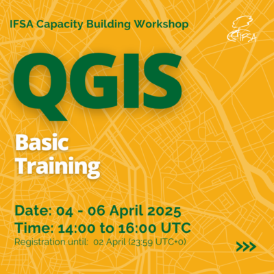
QGIS Basic Training Course for Forestry Applications.
Please be aware that due the large amount of interest that this webinar will not be interactive, questions will be taken on a slido and a followup FAQ will be recorded. Certificates may not be issued or issue will be delayed.
Are you a forestry student looking to develop GIS skills? Join our free online QGIS training workshop, where you’ll learn the fundamentals of GIS and how to use QGIS for forestry applications.
📅 Training Schedule everyday from 14:00 – 16:00 UTC
-
Day 1 (April 4): Introduction to GIS, QGIS & Coordinate Systems – Learn GIS basics, forestry applications (e.g., wildfire mapping, deforestation monitoring), and coordinate systems. Includes a hands-on QGIS interface tour.
-
Day 2 (April 5): Spatial Data Models & Structures – Explore vector (points, lines, polygons) and raster data, data sources, and attribute editing. Hands-on: Import and edit vector data in QGIS.
-
Day 3 (April 6): Spatial Data Visualization – Learn map design, labeling, symbology, and exporting maps. Hands-on: Create and export a study area map.
📍 Where? Online via Zoom
🎓 Who can join? Forestry or simular students with no prior GIS experience
📜 Certification: Participants who complete the training will receive a certificate signed by the IFSA President
🔗 https://us06web.zoom.us/meeting/register/T-Zl4tHjQI-7bhpQnPo7pg
Don’t miss this chance to gain valuable GIS skills! 🚀
For questions, contact workshop@ifsa.net.


